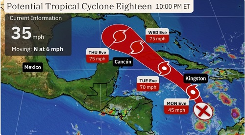
The National Hurricane Center designated the area of low pressure as a Potential Tropical Cyclone
This low could gradually try to spin up a tropical storm by late tonight.
The western Caribbean is an area that has historically seen tropical development in November.
The storm is expected to strengthen to a tropical storm late Sunday night or early Monday morning, moving through the western Caribbean and continuing to strengthen through the first half of the week, and potentially reaching hurricane strength by Wednesday as it nears the Gulf of Mexico.
The next Atlantic storm name is Rafael.
A hurricane watch has been issued for the Cayman Islands. A Hurricane Watch means that hurricane conditions are possible within the watch area in approximately 48 hours.
A tropical storm warning has been issued for Jamaica, which means that tropical storm conditions are anticipated for the region within the next 24 to 36 hours.
Here’s where the PTC 18 might track next: The NHC says the broad Caribbean area of low pressure will drift slowly to the northwest through the next several days, bringing heavy rain to adjacent land areas in the western Caribbean.
It’s possible this system could head into the Gulf of Mexico sometime mid- to late week, but there is no guarantee it will bring any significant impacts to the U.S. Gulf Coast. That’s because wind shear, dry air and cooling Gulf waters might be hostile factors to its ability to stay organized or even remain intact as it tracks farther north.
Residents, however, should monitor the situation over the next several days until the forecast becomes clearer.
What else is happening in the Atlantic Basin: The NHC is also watching a trough of low pressure near Puerto Rico and Hispaniola (labeled system No. 2 below) which will bring local flooding rainfall to those areas over the next several days. Its chance of tropical development is low before it combines with the aforementioned Caribbean disturbance.
The third and final system being watched by the NHC is in the Northern Atlantic. The system became Subtropical Storm Patty early Saturday and will bring gusty conditions to the Azores and the Iberian Peninsula through early week.
Historically, the area in yellow below stretching from the western Caribbean to the Bahamas as well as a separate area in the central Atlantic have had the most instances of named storm formations in November.
The last month of hurricane season generates a storm every one to two years, on average. In the past 10 years, the season’s last storm fizzled as early as Oct. 28 and as late as Dec. 7.
But 2022 was quite the opposite, with Martin and Nicole developing into November hurricanes. Lisa also intensified into a hurricane during the month after forming as a tropical storm on Oct. 31.
Nicole eventually went on to strike the Atlantic coast of Florida as a Category 1, becoming just the fourth November hurricane to landfall in the mainland U.S. in records dating to the mid-19th century.


Leave a Reply